
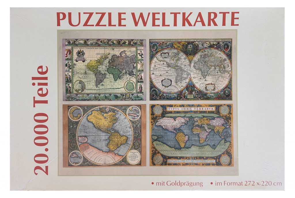
In the series „Mapping the World …with Maria“ I want to present some special map puzzles from my jigsaw collection. Quarterly, you can find this blog at the BCD Jigsaw Magazin so hurry up and join us! https://www.thebcd.co.uk/online-joining-form/
‚The Big One‘ is the 20k-piece-puzzle published by WELTBILD showing 4 antique maps.
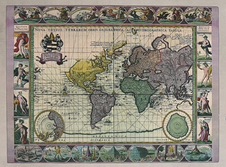
Upper left: “Nova Totius Terrarum Orbis Geographica Ac Hydrographica Tabula”
(New geographic and hydrographic map of the whole world), from „The English Atlas“ by Moses Pitt (Oxford, 1680).
Originally, this map plate was engraved by Joshua van den Ende in 1606 for Willem Blaeu’s Atlas. Often copied, changed and updated, the showing world map is the last state finished by Moses Pitt and Steven Swart in 1680.
The impressive detailed borders showing allegorical figures of the sun, the moon and the five knowing planets (top), the for elements (left) and the for seasons (right). At the bottom, the seven world wonders are illustrated.
Since the first engraved in 1606, the chart has been updated: Nova Hollandia (former Australia) has been added in part outline and California is now shown as an island. The two polar maps and the western coast of America have been redrawn with more details.
The cartouche inside the map chart shows the arms of Pitt’s patron, the Lord Bishop of Oxford.
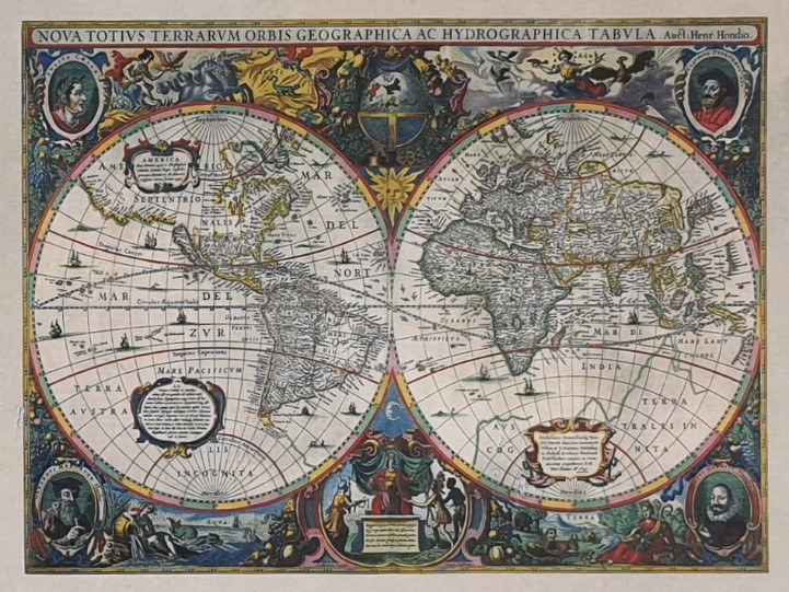
Upper right: „Nova Totius Terrarum Orbis Geographica ac Hydrographica Tabula“
(New geographic and hydrographic map of the whole world), c1631-1641 by Henricus Hondius (1597 – 1651).
In 1629 Jan Jansson and his partner Henricus Hondius set about updating the Mercator-Hondius Atlas (first issues dated from 1585/1606). The two hemispheres are bordered by allegories of the four elements: Fire (Ignis), Air (Aer), Water (Aqua) and Earth (Terra). In each corner there are portraits of famous people (from upper left to lower right): Julius Caesar, Claudius Ptolemy, the author’s father Jodocus Hondius, his mentor Gerard Mercator.
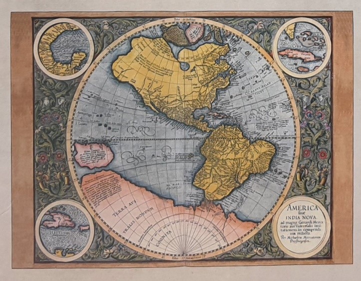
Lower left: „America sive India Nova ad magnae Gerardi Mercatoris avi Universalis imitationem in compendium redacta. Per Michaelem Mercatorem Duysburgensem“
„America or New India reduced to a compendium in imitation of the great Gerard Mercator, the grandfather of Universal. By Michael the Merchant of Duisburg.“ aprox. 1600
Antique map of America (Western Hemisphere), by Gerard Mercator, Duisburg (Germany), 1595. Engraved by G. Mercators‘ son, Michael. With 3 insets, small corner circular maps: Gulf of Mexico; Cuba and Hispaniola.
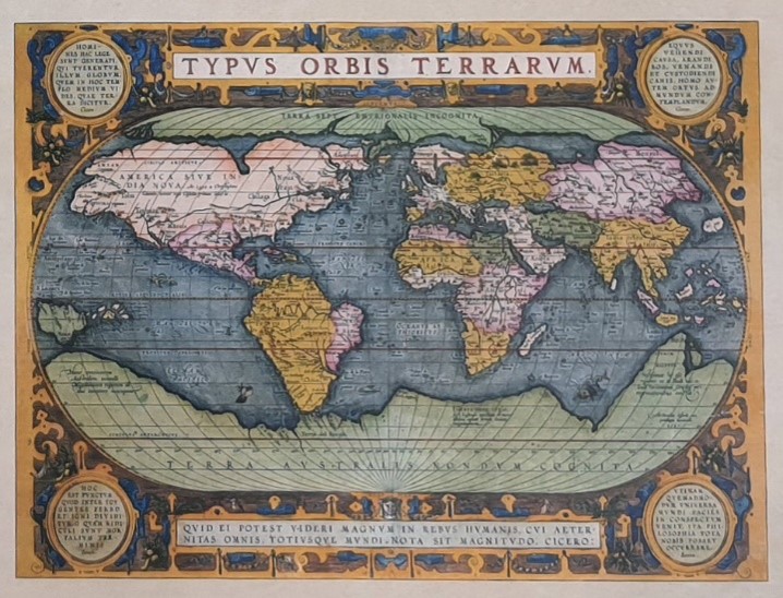
Lower right: „Typus Orbis Terrarum“
(Map of the known World)
A world map from Abaham Ortelius atlas „Theatrum Orbis Terrarum“ from the 1590s. The map exists in different versions and colours.
This one includes some decorative borders with cartridges containing quotes from Cicero and Senec.